
- Electric Vehicle Infrastructure Plan. (June 2017).
- Urbanized Area Boundary 2020 Draft Map (Updated January 2024)
- Tompkins County (NY) Highway Functional Classification Map (Updated March 2018)
- Multi-Use Trails Maps: The City of Ithaca and Tompkins County, N.Y. (Updated 2023)
- Tompkins Priority Trails Strategy: 2023 Update
- Complete Streets Network Map (November 2020)
-
Ithaca & Tompkins County Bicycle Map (Updated 2024)
- Archived documents listed at the bottom of this page are available upon request
Electric Vehicle Infrastructure Plan.
For the most recently updated information visit the Facebook page at https://www.facebook.com/EVTompkins/
From 2016 to mid-2017, an “Electric Vehicle (EV) Infrastructure Plan for Tompkins County” was coordinated by the Ithaca-Tompkins County Transportation Council who, with several other key organizations in the area, formed a Steering Committee to oversee this effort. The purpose of this project was to support Tompkins County in the transition to increased electric vehicle use and to help communities prepare and encourage EV adoption and use.
 Infrastructure Plan 2-page Overview.
Infrastructure Plan Executive Summary
The project reports and criteria tool are described below and can be reached by clicking on the highlighted title.
- Existing Conditions and Best Practices summarized the current conditions for EV use in Tompkins County, and best practices in the establishment of a charging station network.
- EV Charging Station Site Suitability identified a set of optimal locations for EV charging stations in Tompkins County using a Criteria Tool.
- Preliminary Engineering and Cost Analysis for EV Charging Stations documented the recommended strategy for installing new EV charging stations at seven different locations in Tompkins County that showed good potential based on the Criteria Tool.
- Charging Station Implementation Strategies summarizes opportunities to expand the EV charging station network in Tompkins County.
Tompkins County (NY) Highway Functional Classification Map
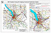 Map of the Federal Aid eligible roads in Tompkins County and their functional classifications. Prepared by the ITCTC, updated 3/13/2018.
Complete Streets Network Map
(Prepared by the ITCTC)
The Planning Committee of the ITCTC has identified a well coordinated network of roads to form a Complete Streets Network for the urbanized area of Tompkins County. A ‘Complete Street’ is a street designed and operated to enable safe access for all users regardless of their mode of transportation, so that pedestrians, bicyclists, motorists or public transportation users of all ages and abilities are able to move safely along and across the street.
Urbanized Area Boundary Map (UAB)
(Prepared by the ITCTC)
-
Urbanized Area Boundary 2020 Map (Updated January 2024)
Section 101 of Title 23 USC, mandates that an Urbanized Area Boundary (UAB) be fixed around urban areas of over 50,000 population, as determined by the United States Bureau of the Census. In urbanized areas, the designation of the Urbanized Area Boundary shall be based on the continuing, cooperative and comprehensive transportation planning process carried on by state and local communities. The US Census Bureau, the NY State Department of Transportation and the ITCTC collaborated to update the Ithaca Urbanized Area map to accommodate the results of the 2020 Census. The 2020 Urbanized Area Boundary was redefined by the United States Bureau of the Census based upon housing density and population as identified in the 2020 Census. NYSDOT, in coordination with the ITCTC, adjusted the Census defined boundary to accommodate exiting conditions. The 2020 Adjusted Census Defined Ithaca Urban Area boundary is shown in this map.
Multi-Use Trails in Tompkins County, N.Y., (updated 2023)
 These maps show the status of the planned multi-use trail network for Tompkins County (refer to the 1996 Transportation Trail/Corridor Study). Trails are color-coded on the maps to show existing, in progress, proposed, and to be built. Trails shown as existing have been built and are open to the public. Trails in progress are those that have been allocated funding and are at some stage in their design or construction. Proposed trails are those that have been identified in plans but have not been funded or advanced in any other way. View the maps:
-
Multi-Use Trails in Tompkins County, N.Y. (updated 2023)
-
Multi-Use Trails in The City of Ithaca (updated 2023)
Tompkins Priority Trails Strategy: (2023 update)
The priority trails in this Strategy are a subset of the larger trail network in Tompkins County and represent the key components needed to advance implementation of the envisioned countywide multi-use trail network. This document includes descriptions, parties involved, current status/recent accomplishments, action items, and future phases for the following priority trails:
• Dryden Rail Trail
• South Hill Recreation Way Extension
• Black Diamond Trail: Extension to Trumansburg and Connection between Buttermilk and Robert H. Treman State Parks
• Urban Connectors
• Finger Lakes Trail
Ithaca & Tompkins County Bicycle Map (updated 2024)

The ITCTC updates a bicycle suitability map of Tompkins County roads approximately every two years. The finished product is a user-friendly full-color road map of the City of Ithaca and Tompkins County offered to the public for free. Our 2024 map has been updated with current road conditions for biking as well as the addition of points of interest (swimming areas, farmers' markets, waterfalls, bike repair locations, parks, trails, visitor's centers, and more). Hard copies are available now. Preview the 2024 map below:
Archived documents available upon request:
- Transportation Trail Corridor Study - (1996)
- Northeast Subarea Transportation Study (NESTS) - (1999)
- Freight Transportation Study (FTS) - (2002)
- Tompkins County Pedestrian Facilities Inventory Data Report - (2002)
- Northeast subarea Transportation Study Transit Planning Project (NTTP) - (2003)
- Park and Ride Feasibility Study - Phase I (2005) - Phase II (2006) - Summary Report (2006)
- Ithaca Neighborhood Greenways Study and Proposed Plan - (2011)
- Tompkins County Rideshare Coalition Final Report - (2013)
- TOMTRAN Final Report - (1986)
- TOMTRAN I and II Grant Narrative - (1982)
- TOMTRAN ARC Application - Problem Statement - (1981)
- TOMTRAN Part IV Grant Proposal - (1981)